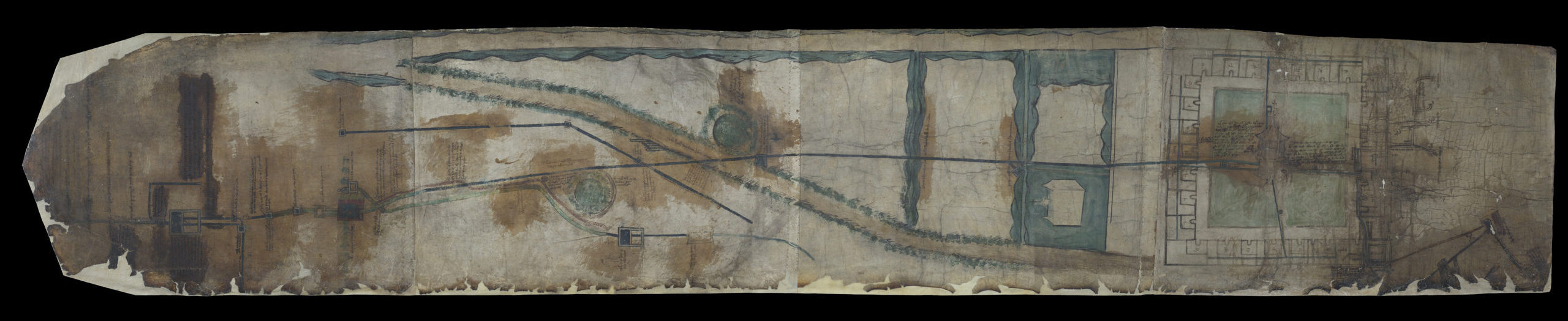
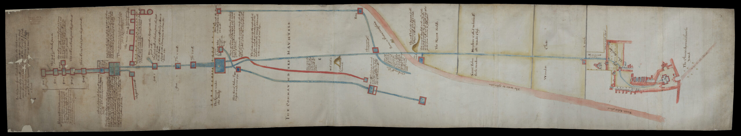
Historic water maps
Our unique collection of four illustrated manuscripts shows the supply of running water to the Charterhouse from its early period as a medieval monastery.
The water maps were made between c.1450 and c.1624, and include the first known image of the Charterhouse, and some of the earliest depictions of what today is part of the London Borough of Islington.
The maps are essentially technical drawings made to assist with the maintenance of the pipes, gutters and filters through which water flowed on its way from springs in Barnsbury to the Charterhouse. The first map was created c.1450, and as the infrastructure at the Charterhouse was repaired and updated, so too was its documentation. Three later versions of the original map chart the changes to the water system and the Charterhouse buildings. The fourth water map, made c.1624, depicts the Charterhouse in its new incarnation as an almshouse and school – known as Sutton’s Hospital.
Medieval water maps
Water maps 1 and 2 date from the medieval period and the time of the monastic London Charterhouse, founded in 1371.
17th-century water maps
Maps 3 and 4 date from the early 17th century, when the charity known as Sutton’s Hospital occupied the site.
The water system shown on these four maps was used until the 18th century, and served the Charterhouse as a monastery, a private mansion and finally as a charity. However, as London expanded and the area around the Charterhouse became increasingly developed, there was a greater risk of water sources becoming contaminated. As a result, and with the cost of maintaining the old system, the Governors of Sutton’s Hospital made a decision in 1767 to abandon reliance on it in favour of water supplied by the New River Company.
Despite becoming obsolete centuries ago, the water maps survive as a valuable resource for the study of medieval and early modern infrastructure and mapping. They are part of the Charterhouse collections, and are preserved and made available to see in our museum display on annual rotation. Our 2025 digitisation project in partnership with The London Archives and Codex Conservation, with a grant from the Paul Mellon Centre for Studies in British Art, has made them available online for the first time.
The digitisation of the Charterhouse’s historic water maps has been supported by the Paul Mellon Centre for Studies in British Art.