17th-century water maps
The two water maps on paper date from after the foundation of the charity known as Sutton’s Hospital.
Following the dissolution of the London Charterhouse in 1537, the site and buildings were remodelled as a Tudor mansion in 1545, after which they were once again adapted – this time to become the home of a new charity. Thomas Sutton bought the Charterhouse for £13,000 in 1611, and he left instructions for it to be converted into what he called his ‘Hospital’. Sutton’s Hospital comprised an almshouse for 80 elderly men or ‘Brothers’, and a school for 40 boys.
Water Map 3
Little is known about the third map in the collection, and we haven’t found any evidence to date it beyond its similarities to Map 4, which is from c.1624.
The high-quality image can take some time to load
Description:
Size: 2234mm x 435mm
Date: Unknown, early 17th-century
Media: Paper, inscribed with suspected iron gall ink and blue (suspected azurite), red (suspected vermillion).
Description: A plan of the water system serving the Charterhouse.
Significance: Unknown.
Provenance: Water Map 3 was made for Sutton’s Hospital and has been in the charity’s archive since its creation.
Water Map 4
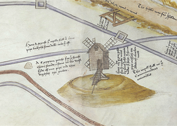
Map 4 is a copy or alternate version of Map 3, written in a different hand, and it includes an illustration of the buildings of Sutton’s Hospital. The buildings are not to scale, but significant features include the almshouses, the chimneys of Wash-house Court, adapted monastic gateways, and the gardens. Inscriptions in a second hand record the cleaning of the wells, vaults and pipes in 1624 ordered by Sir Robert Dallington, Master of the Charterhouse, and help us to date the map.
The high-quality image can take some time to load
Description:
Size: 2480mm x 420mm
Date: c.1624
Media: Paper, inscribed with suspected iron gall ink and blue (suspected azurite), red (suspected vermillion).
Description: A plan of the water system serving the Charterhouse. The plan shows pipes running south and terminating at the conduit of Sutton’s Hospital.
Significance: Water Map 4 contains the earliest illustrations of the buildings of Thomas Sutton’s almshouse and school (except for Francis Carter’s architectural plans of 1613).
Provenance: Map 4 was made for Sutton’s Hospital and has been in the charity’s archive since its creation.
Medieval maps
The Medieval maps date from the time of the Carthusian Monastery – known as London Charterhouse – founded in 1371.
Read moreThe digitisation of the Charterhouse’s historic water maps has been supported by the Paul Mellon Centre for Studies in British Art.