Medieval water maps
Our earliest water maps date from the medieval monastic period when the Charterhouse was known as the London Charterhouse, and was the largest Carthusian monastery in Britain.
The construction of a dedicated water supply for the Carthusian monks began in 1430, and the first water map was created within about 20 years of the first pipes being laid. The supply of water was important to monasteries because they needed to be self-sufficient. These private water systems were not unusual, and there are surviving water maps from other monasteries.
The Carthusian monks were given permission by landowners, Margery and John Feriby, to bring water from the springs of Overmede in Barnsbury, to their monastery on the edge of the City of London. Agreements were also signed with the Order of St John and the Convent of St Mary, whose fields the pipes would need to cross. The water system was constructed across 1.5 miles (2.4km) of countryside between the spring and the monastery.
Water Map 1
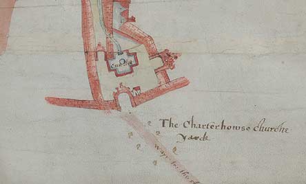
We believe that this map was created as a working document, it is three metres long and would have been stored as a roll for access. Several hands can be identified making annotations over many years as repairs and alterations were made to the water system. Its exact date is unknown, but it is likely that it post-dates the construction of the water system itself. It contains the earliest depiction of the Charterhouse buildings; with a detailed plan of the priory church with its tall spire, the chapter house and little cloister, the individual monks’ cells and the walled gardens of the great cloister. At the centre of the great cloister is the terminus of the water system with its octagonal water tower.
The high-quality image can take some time to load
Description:
Size: 3050mm x 521mm
Date: c.1450
Media: Parchment, inscribed with suspected carbon-based black ink and green pigment, possibly Verdigris mix, and some red, possibly vermillion. Written in suspected iron gall ink.
Description: A plan of the water system serving the London Charterhouse. The plan shows pipes running south and terminating at the monastery.
Significance: The plan of the monastic buildings at the bottom of the document is the earliest known representation of the London Charterhouse. The floorplan was shown by archaeology in the 1940s to be accurate and to scale. The inscriptions, in several distinct hands, record the ownership of land in Islington with references to the Order of St John and St Mary’s Nunnery.
Provenance: Map 1 was presented to the Society of Antiquaries in 1746 and was identified as belonging to the London Charterhouse. It was acquired by the Master, Nicholas Mann, and has remained at the Charterhouse ever since.
Water Map 2
This copy of the first map was made in the 16th-century. The parchment is in better condition than Map 1, the colours are brighter and the handwriting is easier to read. We believe that it was made after 1511, as one of the annotations records that the wells and gutters were cleaned and the pipes renewed in this year. Unlike Map 1, it does not include a plan of the Charterhouse buildings, however there are visible holes in the parchment where a fourth sheet would have been attached with stitches. It is most likely that the London Charterhouse would have appeared on this section.
The high-quality image can take some time to load
Description:
Size: 2680mm x 598mm
Date: c.1511
Media: Parchment, inscribed with suspected iron gall ink and green/yellow pigment (orpiment/Verdigris mix?).
Description: A plan of the water system serving the London Charterhouse.
Significance: Map 2 is a copy of Map 1, with the same inscriptions. The inscriptions are more easily legible, and illustrations of local topographical features are clearer and more decorative.
Provenance: Unknown.
17th-century water maps
The 17th-century maps date from just after the foundation of our Sutton's Hospital.
Read moreThe digitisation of the Charterhouse’s historic water maps has been supported by the Paul Mellon Centre for Studies in British Art.